
Hiking Mount Battie
A short climb to Maine's most iconic view. Mount Battie Trail delivers Camden Harbor and Penobscot Bay in just half a mile.
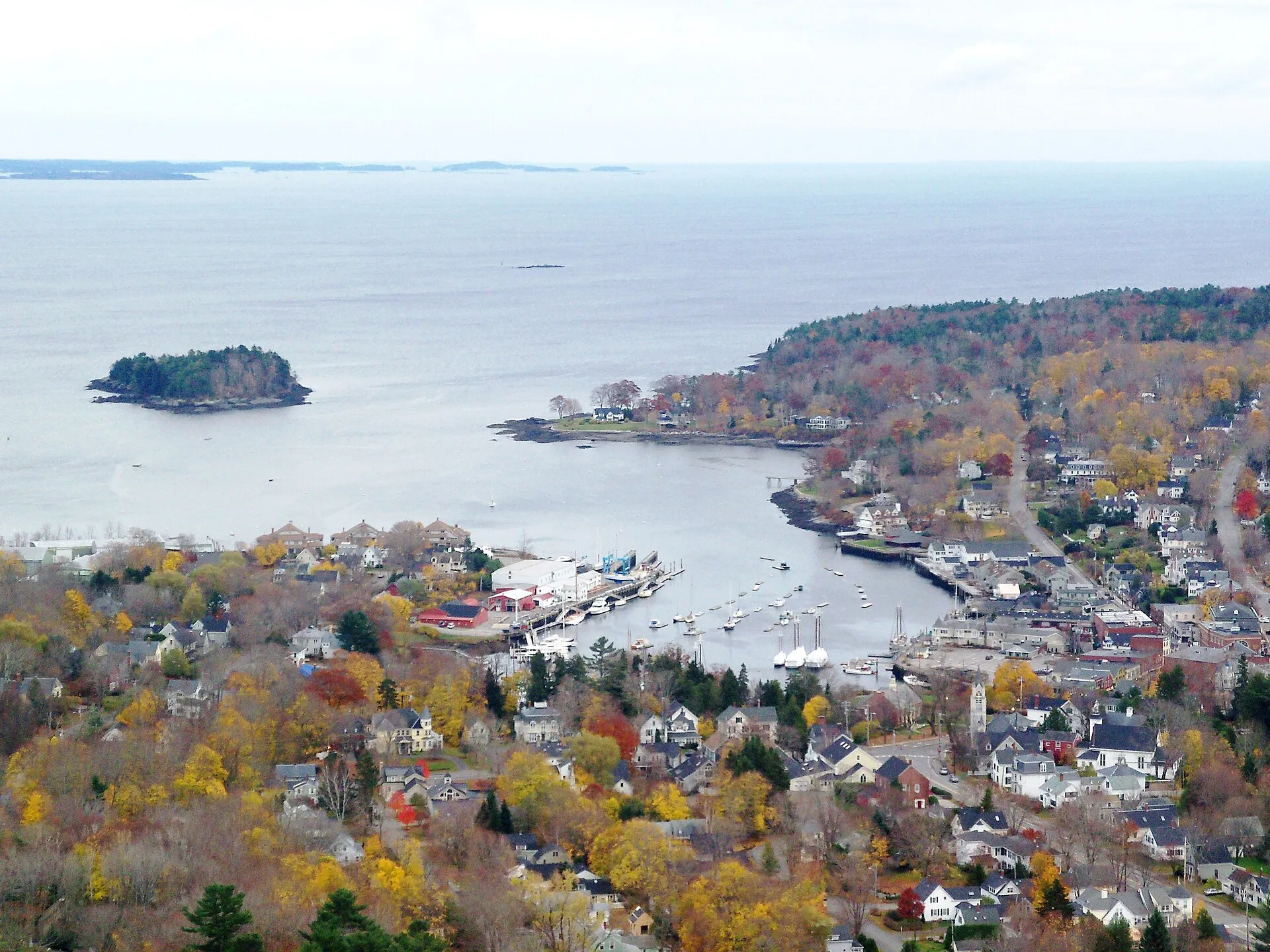
Mount Battie is Maine’s postcard summit. From the stone tower at its 780-foot peak, Camden Harbor spreads below like a model village, sailboats dot the blue expanse of Penobscot Bay, and islands march to the horizon. It’s the view that launched a thousand calendars, and inspired Edna St. Vincent Millay’s breakthrough poem.
The best part: earning this view requires only half a mile of hiking. The Mount Battie Trail climbs steeply but briefly from the base of Camden Hills State Park to the famous outlook. For those who prefer driving, an auto road reaches the same summit. Either way, the view delivers.
The Trail
Statistics
- Distance: 0.5 miles (one way)
- Elevation gain: ~600 feet
- Difficulty: Moderate to strenuous (steep but short)
- Time: 30-45 minutes up, 20-30 minutes down
- Trailhead: Camden Hills State Park entrance
The Climb
The Mount Battie Trail wastes no time. From the trailhead near the park entrance, it heads directly uphill through mixed forest, oak, birch, and spruce providing intermittent shade.
What to expect:
- Steady, unrelenting grade
- Rocky footing requiring attention
- Occasional stone steps
- Switchbacks in steeper sections
- Tree cover until near the summit
The trail is well-marked and well-maintained but genuinely steep. This is a workout compressed into a short distance.
The Summit
You emerge from the trees onto an open granite summit. The stone observation tower rises ahead. Climb inside for 360-degree views through its open top.
The view includes:
- Camden Harbor directly below
- Penobscot Bay spreading east
- Islands: Islesboro, North Haven, Vinalhaven, and more
- The Camden Hills ridgeline continuing north to Mount Megunticook
- On clear days, the mountains of Acadia on the horizon
The Tower
The stone tower was built in 1921 as a memorial to Camden residents who served in World War I. Simple and sturdy, it provides the perfect platform for the view. Stairs inside lead to the open top.
Alternatives to Hiking
Auto Road
A paved road climbs to the Mount Battie summit from within Camden Hills State Park, offering the same view without the hike. The Bureau of Parks and Lands states that Mt Battie Road closes at 4:00 p.m. daily, and closes for the winter on 1 December or whenever snow blocks it.
Details:
- The road is included in park admission, which is charged per person, not per car
- Gate down at 4pm, so a sunset drive up is not possible
- Parking at summit
- Accessible for those unable to hike
Carriage Trail
A longer, gentler route to the summit following the old carriage road.
- Distance: 1.0 mile (one way)
- Difficulty: Moderate
- Character: Wider path, more gradual grade
Good option for those wanting less intensity or a loop hike.
The Loop
Many hikers ascend via the Mount Battie Trail and descend via the Carriage Trail (or vice versa), creating a 1.5-mile loop with variety.
Practical Information
Getting There
Camden Hills State Park entrance is on Route 1, about 2 miles north of downtown Camden.
Address: 280 Belfast Road, Camden, ME 04843
Parking: Main lot near the park entrance and trailhead.
Fees
Maine charges state park day use per person, not per vehicle, which catches people out when they arrive as a family. At Camden Hills that is:
| Maine resident adult | $4 |
| Non-resident adult | $6 |
| Non-resident senior | $2 |
| Children 5-11 | $1 |
| Under 5, and Maine residents 65+ | Free |
An annual vehicle pass is $105 and a senior citizen annual vehicle pass, 65 and over, is $45. Note that the state publishes two different prices for the Individual Pass, $45 on its annual passes page and $55 on its day-use fees page, so confirm before buying. Bring cash: only about 15 state park locations take cards, and only when the booth is staffed.
Hours
The Bureau of Parks and Lands gives Camden Hills as open all year, 8:00 a.m. to sunset daily, unless otherwise posted at the gate. Note that is 8am, not sunrise, so an early start is not as early as you might plan. Park entry is 2 miles north of Camden on Route 1. The auto road closes at 4:00 p.m. daily and for the winter on 1 December.
When to Hike
Best times:
- Early morning (beat crowds, cooler temperatures)
- Late afternoon (golden light on the bay)
- Weekdays (less crowded than weekends)
Seasonal notes:
- Summer: Most crowded but best weather
- Fall: Spectacular foliage, thinning crowds
- Spring: Muddy conditions possible; check before hiking
- Winter: Trail may be icy; use traction devices
What to Bring
- Sturdy footwear with good grip (trail is rocky)
- Water (the climb is short but sweaty)
- Camera (the view demands it)
- Layers (summit can be breezy)
- Snacks (enjoy them at the top)
Tips for the Best Experience
Beat the Crowds
The summit can be busy, especially when the auto road is open. For relative solitude:
- Come early in the day, before the auto road brings the summit crowd. The park gate itself does not open until 8am
- Visit on weekdays
- Come in shoulder season
Photography
- Morning light illuminates the harbor
- Sunset creates silhouettes and warm tones
- The tower frames nicely against sky
- Wide angle captures the panorama
- Telephoto picks out boats and islands
Extend Your Hike
Mount Battie is just the beginning of Camden Hills’ trail network:
- Ridge Trail: Continues to Mount Megunticook (Maine’s highest mainland coastal peak)
- Tablelands: Open ridge with ocean views
- Ocean Lookout: Dramatic viewpoint on Megunticook
A traverse from Battie to Megunticook and back makes a substantial day hike.
The Millay Connection
Edna St. Vincent Millay grew up in Camden and climbed Mount Battie as a girl. Her poem “Renascence” opens with the view:
“All I could see from where I stood Was three long mountains and a wood; I turned and looked another way, And saw three islands in a bay.”
The poem launched her literary career. The view remains unchanged.
The Experience
The trail tilts up immediately. Your breath quickens. Roots and rocks demand attention. This is not a stroll. It’s a climb, compressed and concentrated.
But half a mile is half a mile. Just when your legs start questioning your choices, the trees thin and granite appears underfoot. The tower rises ahead. You’ve arrived.
The view opens all at once. Camden shrinks to dollhouse scale below. The harbor is a perfect postcard, white sailboats, church steeples, the arc of the waterfront. Beyond it, Penobscot Bay spreads impossibly blue, islands scattered across its surface like stepping stones to the horizon.
You climb the tower stairs and emerge into wind and light. The world extends in every direction. The effort of the climb dissolves into the reward of the view.
This is why people come to Camden, distilled to its essence: the mountains meeting the sea, and a summit that delivers both in a single, sweeping glance.
Mount Battie asks for half a mile of effort and returns one of Maine’s most celebrated views. Drive or hike. Either way, stand in that tower and look out at the bay. You’ll understand why this modest summit has been drawing visitors for over a century.