
Camden Hills State Park
Mount Battie, Mount Megunticook and 30 miles of trails above Camden Harbor. Verified 2026 fees, hours, the 4pm Mount Battie Road gate, and the 108-site campground.
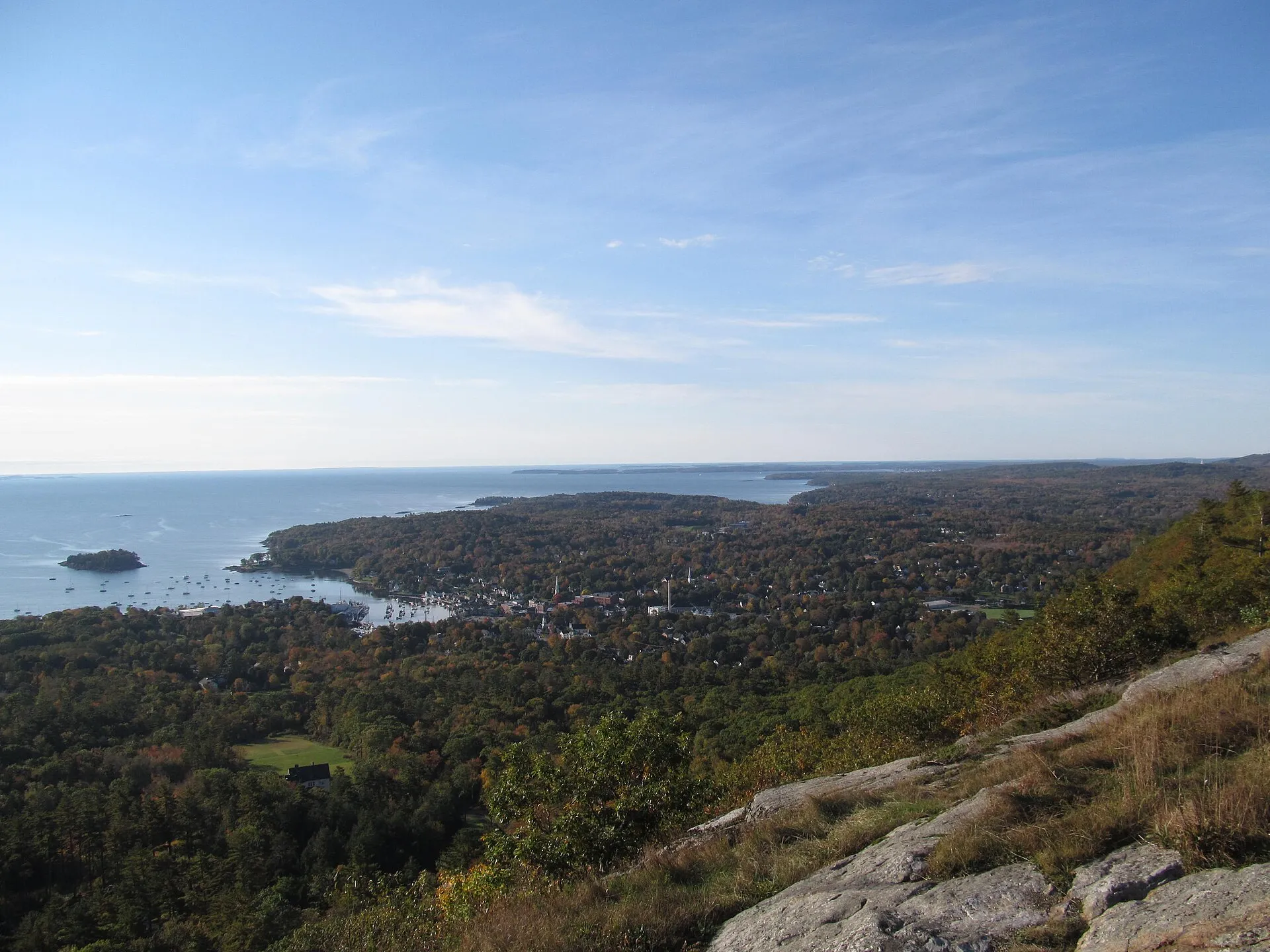
Maine’s Bureau of Parks and Lands calls the vista on top of Mount Battie the park’s “signature location”, and it earns the billing: Camden Harbor directly below, Penobscot Bay opening east, the islands beyond, and Cadillac Mountain on the horizon on a clear day. The state counts over 30 miles of trails behind that one view, running north along a ridge that ends in a quieter half of the park most visitors never reach.
Camden Hills State Park covers the ridgeline that forms the backdrop to Camden village. The park spans two towns: the southern end, with Mount Battie, Mount Megunticook, the auto road and the campground, is in Camden, while the northern end, with Bald Rock Mountain and the trailhead on Route 173, is in Lincolnville.
What it costs
Maine state parks charge day use per person, not per vehicle, for everyone aged 12 and over. At Camden Hills in 2026:
| Adult Maine resident | Adult non-resident | Senior non-resident | |
|---|---|---|---|
| Day use, per person per day | $4 | $6 | $2 |
Children 5 to 11 pay $1, children under 5 are free, and Maine residents 65 and over are free. A carload of four non-resident adults is $24, not one parking fee. The state’s own fee page warns that only about 15 park locations take cards when staff are in the booth, so bring cash.
The fee is collected year round, at the entry booth when it is staffed and at a self-service station when it is not. There is no extra charge for driving the Mount Battie Road.
Annual passes cost $105 for a vehicle pass, which covers everyone in a vehicle of up to 17 seats, and $45 for the senior citizen annual vehicle pass for people 65 and over, which requires ID and is not sold online. The Individual Season Pass is a problem: Maine lists it at $45 on its annual passes page and at $55 on its day-use fees page. Both were live in September 2026. Confirm the price before you buy.
Hours, and the Mount Battie Road
The park is open all year, 8:00 a.m. to sunset, unless otherwise posted at the gate. It is not open at sunrise.
The Mount Battie Road is where the planning goes wrong. Maine’s published park hours say the Mount Battie Road closes at 4:00 p.m. daily. A seasonal conditions update posted on the same park conditions page in May 2026 says the road is open 7:00 a.m. to sunset. Those two statements cannot both be right, and the state has not reconciled them. If you are driving up for late light, call the park first: (207) 236-3109 in season, (207) 236-0849 after Labor Day.
The road closes for the winter on 1 December, or earlier if snow blocks it. It is then plowed all winter for walking, and the park says it is occasionally opened to cars when conditions allow. Everything else stays open: the entrance lot and other access points are plowed, and the fee is still collected.
The road itself was built in the 1960s and ends at the stone tower.
The peaks
Mount Battie, 780 feet. The famous one, reachable on foot or by car, with the stone tower at the top.
Mount Megunticook, 1,385 feet. The highest point in the park and, in the state’s words, “the highest of the Camden Hills”. The summit is wooded, so the views everyone remembers are from Ocean Lookout at 1,300 feet, on the shoulder below it. You will see Megunticook described elsewhere as the highest mainland peak on the Atlantic coast. Maine’s own park page uses the truncated phrase “highest peak on the mainland” without qualifying it, which cannot be read literally in a state that contains Katahdin, so we quote only what the state plainly supports.
Bald Rock Mountain, 1,200 feet. A barren summit at the Lincolnville end of the park, reached from the Multi-use Trail. Maine says many hikers rate this the park’s best view of Penobscot Bay. Two Adirondack shelters and an outhouse sit just below the summit.
Zeke’s Lookout, 1,190 feet, on a short spur off Zeke’s Trail.
Maiden Cliff is not part of the state park. The cliff rises 800 feet above Megunticook Lake, and both the Maiden Cliff Trail and the connecting Scenic Trail are, in the Bureau’s own words, “owned and maintained by Camden’s Parks and Recreation Department”. The park’s Ridge Trail links into that town-owned network.
The trails
Distances and difficulty ratings below are the state’s own, one way, with the time Maine tells you to allow.
| Trail | Distance | Rated | Allow |
|---|---|---|---|
| Mount Battie Trail | 0.5 mi | Moderate to strenuous | 45 min |
| Carriage Road Trail | 0.8 mi | Moderate | 45 min |
| Megunticook Trail | 1.0 mi | Moderate | 1 hr |
| Adams Lookout Trail | 0.3 mi | Easy | 15 min |
| Tablelands Trail | 1.5 mi | Moderate to strenuous | 1.5 hr |
| Ridge Trail | 2.5 mi | Moderate | 2.5 hr |
| Slope Trail | 1.5 mi | Moderate to strenuous | not published |
| Nature Trail | 1.2 mi | Easy to moderate | 1 hr |
| Ski Shelter / Multi-use Trail | 5.0 mi | Easy | 3 hr |
| Bald Rock Trail | 1.3 mi | Easy to moderate | 30 min |
| Zeke’s Trail | 1.3 mi | Moderate | 1 hr |
| Cameron Mtn. Trail | 1.9 mi | Easy | 1.5 hr |
| Frohock Trail | 1.9 mi | Moderate to strenuous | 2 hr |
| Jack Williams Trail | 1.6 mi | Easy to moderate | 1.5 hr |
| Sky Blue Trail | 1.5 mi | Easy to moderate | 1.5 hr |
| Summer Bypass Trail | 0.8 mi | Easy | 30 min |
| Shoreline Trail | 0.3 mi | Easy | 15 min |
| Bubba’s Trail | 0.8 mi | Moderate | 30 min |
| Maiden Cliff Trail (town) | 1.0 mi | Moderate | 1.5 hr |
| Scenic Trail (town) | 0.8 mi | Moderate | 45 min |
Getting up Mount Battie
The Mount Battie Trail is the direct route, half a mile with some steep pitches and, in the state’s description, “a bit of scrambling through rock and ledge areas”. Its lower end is at the park boundary off Route 52, Mountain Street, on the Camden village side of the mountain, not at the Route 1 entrance where the campground and the auto road are.
The Carriage Road Trail is the gentler line, 0.8 mile on the bed of an old carriage road that once served the Summit House, a private clubhouse and social centre on the summit at the turn of the twentieth century. Its lower end also meets Route 52, a little further south. Taking one up and the other down gives you about 1.3 miles of trail plus a short road walk between the two trailheads.
Getting up Mount Megunticook
The Megunticook Trail is short and steep: one mile, climbing nearly 1,000 vertical feet, an hour up. It starts from a lot about a quarter of a mile up the Mount Battie Road and ends at Ocean Lookout, where the state promises Mount Battie below you, Camden at its base, and Penobscot Bay from Acadia to Monhegan, with Mount Washington on the western horizon on a clear day. The Maine Natural Areas Program’s guided version, out the Megunticook Trail and back by the Adams Lookout Trail, is 2.6 miles round trip and reaches the summit at 1.3 miles.
From Ocean Lookout the Ridge Trail carries on 2.5 miles along the ridge top, over the wooded summit, to the town trails near Maiden Cliff. The Slope Trail drops steeply from the summit to the Megunticook Cabin and the Multi-use Trail, which is why many people use it as the way down from a Megunticook Trail ascent rather than the way up.
The Tablelands Trail, not the Ridge Trail, is the link between the two mountains: 1.5 miles from Mount Battie’s summit north over a series of plateaus to Ocean Lookout.
The quiet half
The Ski Shelter / Multi-use Trail runs 5 miles from the campground to ME Route 173, on a graveled, graded surface that takes hikers, bikes, horses, skiers and snowmobiles. It is the spine of the park’s northern half and the access to Bald Rock, Cameron Mountain, Frohock, Zeke’s and Sky Blue trails, plus the Megunticook Cabin at its midpoint. Cameron Mtn. Trail climbs gently through old farmland and blueberry fields; Sky Blue passes a vernal pool. These are the trails where you will not meet the Mount Battie crowd.
The Nature Trail is not a short loop. It runs 1.2 miles from the camping area up the northeast slope to the Tablelands Trail, about an hour, at which point you can turn left for Mount Battie or right for Ocean Lookout and the summit of Mount Megunticook.
Getting there and parking
The entrance is 2 miles north of Camden on U.S. Route 1, known as the Belfast Road north of the village. Park address: 280 Belfast Road, Camden, ME 04843.
There are four separate places to leave a car, and they serve different trails:
- Main entrance and campground, off Route 1. The Multi-use Trail, Nature Trail and the Mount Battie Road all start here.
- Megunticook Trail lot, about a quarter of a mile up the Mount Battie Road on the right.
- Mount Battie summit, at the top of the auto road.
- Route 173 lot, at the northern end of the Multi-use Trail in Lincolnville, for Bald Rock and Frohock.
The Maiden Cliff trailhead is on Route 52 west of Camden village, a separate town-run trailhead outside the park entrance.
Download the park guide and map before you go, and text CAMDEN to 888-514-7527 for the park’s trail condition alerts.
Camping
The campground has 108 sites, each with a picnic table and fire pit, in forest near the park entrance. Some have water and electric hookups. There are hot showers and flush toilets, an RV dumping station, and WiFi in the campground for a small fee. A separate group camping area has 5 tent-only sites, and there is a day-use group picnic shelter with an ocean view available for rental.
Rates are per site per night, for groups of six or fewer:
| Maine resident | Non-resident | |
|---|---|---|
| Standard site | $25 | $35 |
| Water and electric hookup site | $35 | $45 |
Add $5 per site per night for the reservation and 9% Maine lodging tax on top. Camden Hills and Sebago Lake are the two most expensive state park campgrounds in Maine.
Booking
Family camping is booked at CampWithME.com. The pattern is worth understanding, because it is not a rolling window:
- Reservations for the whole coming season open on one morning in early February at 9:00 a.m. For 2026 that was 5 February for all parks.
- Internet booking runs until mid-September. In 2026 it closed on 13 September at 4:00 p.m., and from 14 September every campsite became first come, first served.
- The campground closes at noon on 15 October.
- Group camping and the picnic shelter are booked by phoning the park directly, not online.
Campground visitors who are not staying are allowed between 9:00 a.m. and 8:00 p.m. and pay the day use fee. Quiet hours are 10:00 p.m. to 7:00 a.m., and generators may run 8:00 a.m. to 8:00 p.m.
Winter
Day use continues all winter at the normal fee. The entrance lot is plowed, the Mount Battie Road is plowed for walking, and hiking trails are open for snowshoeing unless posted otherwise. The Multi-use Trail is packed, not track set, for backcountry-style skiing from the main entrance to the Ski Shelter, and 7.6 miles of trail are open to snowmobiles, shared with skiers.
Winter camping is available, contrary to what this page used to say. It runs 15 December to 15 March, primitive tent camping only, and at Camden Hills it is permitted in the group camping area only. There is no water, there are no amenities, and campsites and trails are not cleared. You register on site at the entry booth and pay by cash or check. Call (207) 236-0849.
Megunticook Cabin
The old ski shelter at the junction of the Slope and Multi-use trails is a rustic 20 by 40 foot insulated cabin with a fieldstone fireplace, bunk beds for six, an outdoor vault toilet and no electricity or running water. It sits about 2.5 miles in from the campground parking area and can only be reached on foot, by bicycle, on horseback, on skis or by snowmobile. Cell coverage there is, in the park’s own words, extremely poor.
It is reservable year round by phoning the park, up to a year ahead, six nights maximum. Maine’s cabin brochure lists $54.50 a night for the first six campers and $5.45 for each additional person per night, lodging tax included. That sheet was last revised in 2020, so confirm the rate when you call.
The building has a history: the Civilian Conservation Corps put up the original Megunticook Ski Shelter in the late 1930s as a warming hut at the foot of ski slopes on Megunticook’s north side. There were no lifts; skiers climbed back up after every run. The slopes closed by the end of the 1950s, the shelter fell in, and it was razed in the early 1990s. Park staff rebuilt it in 2005 with lumber cut on park property.
Rules worth knowing
- Pets must be leashed, under the handler’s physical control, and never left unattended. Pick up after them.
- Hunting is not permitted in the park between 1 June and Labor Day, which means it is permitted the rest of the year. Wear blaze orange if you are hiking in autumn.
- Horseback riding is allowed, but on the multi-use trails only.
- Fires only in the fire pits and grills at campsites and picnic sites.
- Buy firewood where you burn it. Moving firewood moves insects and disease.
History
The stone tower on Mount Battie was built in 1921 as a memorial to Camden’s First World War soldiers, and you can still climb inside it. It replaced the Summit House, a hotel and clubhouse built on the summit in 1898 and pulled down around 1920 after it fell out of use. Fire swept Mount Battie in 1918 and again in 1930; the 1930 fire burned for four days while thousands of people fought it.
The park itself began in the 1930s as “Camden Mt. Park”, the work of local residents, federal money, National Park Service approval and Civilian Conservation Corps crews who cut the original trails and put up the original structures.
Edna St. Vincent Millay
The Bureau of Parks and Lands says the view from the top of Mount Battie inspired Millay’s poem Renascence. The Maine Natural Areas Program dates the poem to 1912 and calls Millay a Camden native. It opens:
“All I could see from where I stood / Was three long mountains and a wood; / I turned and looked another way, / And saw three islands in a bay.”
Maiden Cliff
A large steel cross on the cliff top commemorates Elenora French, an 11-year-old girl who went over the edge after her hat when a gust of wind took it. The state gives two different years for it: the Bureau’s trail page says 1862, its own Natural Heritage Hike guide to the trail says 1864. The cliff took her name from the accident.
Two more things the state will tell you
Megunticook is a Penobscot word for the swelling ocean. And the exposed cliff just below Megunticook’s summit is nesting habitat for peregrine falcons, which dive at over 200 miles an hour.
Combining with Camden
The park is minutes from Camden village.
Camden Harbor. The windjammer fleet, the waterfront, the shops.
Camden Opera House, 29 Elm Street, Camden. Check the calendar before you come.
Restaurants and galleries along Main Street, for after the summit.
A workable day: hike Mount Battie or the Megunticook Trail in the morning while the trails are quiet, lunch in the village, and spend the afternoon on the harbour. If you want the auto road too, do it before the gate question becomes urgent.
Safety
- Cliff edges at Maiden Cliff, Ocean Lookout and elsewhere are unprotected.
- Summits are exposed and colder and windier than the base. Carry layers.
- Trails are rocky. The state’s own descriptions mention scrambling on the Mount Battie Trail and steep pitches on the Slope and Tablelands trails.
- In winter, ice on ledge is the hazard, not the snow.
- Cell coverage is generally good in the park, with the notable exception of the Megunticook Cabin area.
Related Guides
Explore more of the Camden area and Maine hiking:
- Mount Battie Guide - Detailed guide to Camden’s signature summit
- Camden Overview - Exploring the village of Camden
- Hiking Guide - Complete guide to hiking in Maine
- Camping Guide - Camping at Camden Hills and beyond
- Best Small Towns Guide - Camden and other charming Maine towns
- Photography Spots Guide - Capturing the view from Mount Battie
- Best Time to Visit Maine - Seasonal considerations
Common Questions
How much does it cost to visit Camden Hills State Park?
Maine charges day use per person, not per vehicle. At Camden Hills in 2026 that is $4 for an adult Maine resident, $6 for an adult non-resident and $2 for a non-resident senior. Children 5 to 11 pay $1, under 5 are free, and Maine residents 65 and over are free. A car with four non-resident adults is $24, not one parking fee. The fee is collected year round at the entry booth or a self-service station, and cash is the safe assumption because only about 15 state park locations take cards.
Can you drive up Mount Battie?
Yes. The Mount Battie Road climbs from the main entrance to the stone tower at the summit, and there is no separate charge for it beyond the per-person day use fee. The catch is the gate. The Bureau of Parks and Lands states in its published park hours that the Mount Battie Road closes at 4:00 p.m. daily, while a seasonal conditions update on the same page says the road is open 7:00 a.m. to sunset. Those two statements conflict, so call the park before planning a late afternoon or sunset drive. The road closes for the winter on 1 December or whenever snow blocks it, and is then plowed for walking rather than driving.
How tall is Mount Battie and how long is the hike?
The Bureau of Parks and Lands gives Mount Battie a 780-foot summit. The Mount Battie Trail is half a mile one way, rated moderate to strenuous, and the park guide says to allow 45 minutes with some steep pitches and scrambling over rock and ledge. The gentler Carriage Road Trail reaches the same summit in 0.8 mile, rated moderate, also about 45 minutes.
Is the Camden Hills campground open in winter?
The regular campground closes at noon on 15 October, but winter camping is available from 15 December to 15 March. It is primitive tent camping in the group camping area only, with no water, no amenities and no cleared campsites or trails. You register on site at the entry booth and pay by cash or check. The Megunticook Cabin, a rustic six-bunk cabin about 2.5 miles in from the campground parking area, can be reserved year round by phoning the park.